 vesseltracker.com
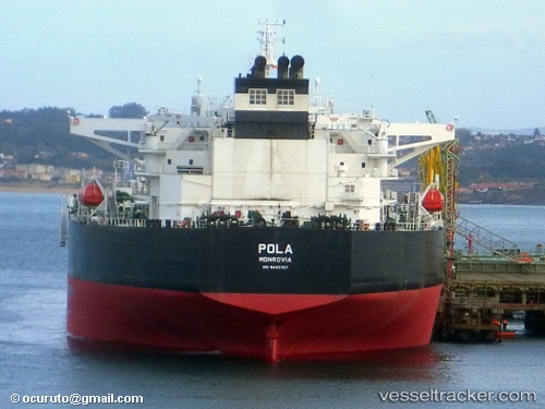
 Pola
Pola
Current Status
Where is the vessel?
Pola is currently in 17 nm N of Muda Marine Terminal, based on AIS data received about 1h ago.
Latest AIS update:
Current position: 7.84833° N, 103.09167° E (17 nm N of Muda Marine Terminal)
Average speed (last 7 days): Loading…
Average speed (last 30 days): Loading…
Vessel profile: Pola is a Crude Oil Tanker with dimensions 274m x 48m.
This page combines live AIS, route history, probable destination signals, nearby traffic, and port activity for practical vessel monitoring.
The current position of vessel Pola is 7.84833 lat / 103.09167 lng. Updated: 2026-04-06 07:35:40 UTCNearest reference points:
- Near Muda Marine Terminal
- 23 nm E of Muda Marine Terminal
- 45 nm NW of Muda Marine Terminal
Currently sailing under the flag of Liberia ![]()
Pola built in 2011 year
Deadweight:
149996 tDetails:
Live Vessel Pola Analytics (details, animations, etc.)
Recent AIS points (UTC):
2026-04-06 01:35:41 UTC · 6.79667, 103.55333 · SOG 10 kn · COG -1°2026-04-06 02:32:39 UTC · 6.95500, 103.47833 · SOG 10 kn · COG -1°
2026-04-06 05:05:40 UTC · 7.38833, 103.28333 · SOG 11 kn · COG -1°
2026-04-06 07:35:40 UTC · 7.84833, 103.09167 · SOG 12 kn · COG -1°