 vesseltracker.com
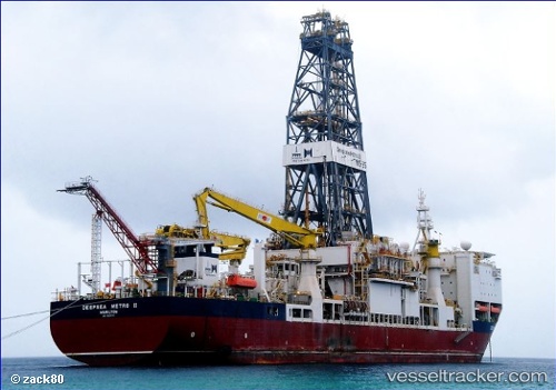
 Fatih
Fatih
Current Status
Where is the vessel?
Fatih is currently in 67 nm N of Cide, based on AIS data received about 17h ago.
Latest AIS update:
Current position: 43.02057° N, 32.88285° E (67 nm N of Cide)
Average speed (last 7 days): Loading…
Average speed (last 30 days): Loading…
Vessel profile: Fatih is a Drilling Ship with dimensions 229m x 36m.
This page combines live AIS, route history, probable destination signals, nearby traffic, and port activity for practical vessel monitoring.
The current position of vessel Fatih is 43.02057 lat / 32.88285 lng. Updated: 2026-04-17 03:17:00 UTCNearest reference points:
- 27 nm NW of INEBOLU
- 18 nm NW of INEBOLU
- Near Cide
Currently sailing under the flag of Turkey ![]()
Fatih built in 2011 year
Deadweight:
34256 tDetails:
Live Vessel Fatih Analytics (details, animations, etc.)
Recent AIS points (UTC):
2026-04-16 06:06:44 UTC · 43.02049, 32.88288 · SOG 0 kn · COG 94°2026-04-17 03:17:00 UTC · 43.02057, 32.88285 · SOG 0 kn · COG 95°
2026-04-17 03:17:00 UTC · 43.02057, 32.88285 · SOG 0 kn · COG 95°
2026-04-17 03:17:00 UTC · 43.02057, 32.88285 · SOG 0 kn · COG 95°