 vesseltracker.com
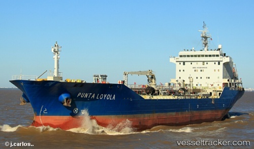
Punta Loyola
Current StatusWhere is the vessel?
Punta Loyola is currently in Near Ingeniero Buitrago, based on AIS data received less than 1h ago.
Latest AIS update:
Current position: 33.38167° S, 60.08833° W (Near Ingeniero Buitrago)
Average speed (last 7 days): Loading…
Average speed (last 30 days): Loading…
Vessel profile: Punta Loyola is a Chemical Oil Products Tanker with dimensions 23m x 144m.
This page combines live AIS, route history, probable destination signals, nearby traffic, and port activity for practical vessel monitoring.
The current position of vessel Punta Loyola is -33.38167 lat / -60.08833 lng. Updated: 2026-04-19 13:19:15 UTCNearest reference points:
- 10 nm NW of San Pedro
- Near Quebracho/San Lorenzo
- Near Puerto Alumbrera
Details:
Live Vessel Punta Loyola Analytics (details, animations, etc.)
Recent AIS points (UTC):
2026-04-19 09:27:12 UTC · -32.88629, -60.68198 · SOG 9.5 kn · COG 159°2026-04-19 10:46:42 UTC · -33.06290, -60.54772 · SOG 13 kn · COG 130°
2026-04-19 12:19:16 UTC · -33.25167, -60.27833 · SOG 13 kn · COG -1°
2026-04-19 13:19:15 UTC · -33.38167, -60.08833 · SOG 14 kn · COG -1°