 vesseltracker.com
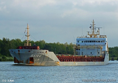
 KATE C
Current Status
Where is the vessel?
KATE C is currently in Near MILOS, based on AIS data received about 1d ago.
Latest AIS update:
Current position: 36.70793° N, 24.44784° E (Near MILOS)
Average speed (last 7 days): Loading…
Average speed (last 30 days): Loading…
Vessel profile: KATE C is a General Cargo Ship with dimensions 110m x 16m.
This page combines live AIS, route history, probable destination signals, nearby traffic, and port activity for practical vessel monitoring.
The current position of vessel KATE C is 36.70793 lat / 24.44784 lng. Updated: 2026-04-10 07:41:08 UTCNearest reference points:
- 17 nm W of Milos (Adamas)
- Near Kéa (Tzia)
- Near PISO LIVADI
Currently sailing under the flag of Portugal (MAR) ![]()
KATE C built in 2010 year
Deadweight:
6795 tDetails:
Live Vessel KATE C Analytics (details, animations, etc.)
Recent AIS points (UTC):
2026-04-10 02:16:52 UTC · 37.08278, 24.13900 · SOG 7.9 kn · COG 148°2026-04-10 04:02:24 UTC · 36.89542, 24.27257 · SOG 8.3 kn · COG 150°
2026-04-10 05:34:03 UTC · 36.72911, 24.41265 · SOG 7.7 kn · COG 141°
2026-04-10 07:41:08 UTC · 36.70793, 24.44784 · SOG 0 kn · COG 227°