 vesseltracker.com
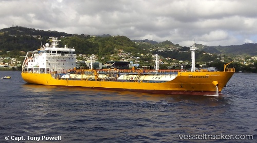
 SAINT JAMES LG
Current Status
Where is the vessel?
SAINT JAMES LG is currently in Near POINT LISAS, based on AIS data received about 1h ago.
Latest AIS update:
Current position: 10.36833° N, 61.51333° W (Near POINT LISAS)
Average speed (last 7 days): Loading…
Average speed (last 30 days): Loading…
Vessel profile: SAINT JAMES LG is a Lpg Tanker with dimensions m x m.
This page combines live AIS, route history, probable destination signals, nearby traffic, and port activity for practical vessel monitoring.
The current position of vessel SAINT JAMES LG is 10.36833 lat / -61.51333 lng. Updated: 2026-04-18 19:49:26 UTCNearest reference points:
- Near POINT LISAS
- Near Caroni
- Near Carenage
Currently sailing under the flag of Malta ![]()
Details:
Live Vessel SAINT JAMES LG Analytics (details, animations, etc.)
Recent AIS points (UTC):
2026-04-18 13:54:17 UTC · 10.36927, -61.51490 · SOG 0 kn · COG 96°2026-04-18 16:15:10 UTC · 10.36909, -61.51490 · SOG 0 kn · COG 84°
2026-04-18 17:48:23 UTC · 10.36910, -61.51492 · SOG 0.1 kn · COG 86°
2026-04-18 19:49:26 UTC · 10.36833, -61.51333 · SOG 0 kn · COG -1°