 vesseltracker.com
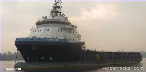
Gerard Tide
Current StatusWhere is the vessel?
Gerard Tide is currently in Near Carenage, based on AIS data received less than 1h ago.
Latest AIS update:
Current position: 10.68167° N, 61.59667° W (Near Carenage)
Average speed (last 7 days): Loading…
Average speed (last 30 days): Loading…
Vessel profile: Gerard Tide is a Offshore Tug Supply Ship with dimensions 19m x 87m.
This page combines live AIS, route history, probable destination signals, nearby traffic, and port activity for practical vessel monitoring.
The current position of vessel Gerard Tide is 10.68167 lat / -61.59667 lng. Updated: 2026-04-18 10:01:26 UTCNearest reference points:
- Near CARENAGE
- Near Carenage
- Near Caroni
Details:
Live Vessel Gerard Tide Analytics (details, animations, etc.)
Recent AIS points (UTC):
2026-04-18 03:36:22 UTC · 10.68234, -61.59775 · SOG 0 kn · COG 0°2026-04-18 06:21:22 UTC · 10.68235, -61.59776 · SOG 0 kn · COG 1°
2026-04-18 07:24:22 UTC · 10.68233, -61.59779 · SOG 0 kn · COG 0°
2026-04-18 10:01:26 UTC · 10.68167, -61.59667 · SOG 0 kn · COG -1°