 vesseltracker.com
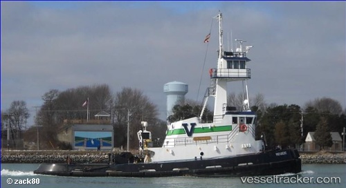
 Patuxent
Current Status
Where is the vessel?
Patuxent is currently in Near Port Newark, based on AIS data received about 1h ago.
Latest AIS update:
Current position: 40.66967° N, 74.08217° W (Near Port Newark)
Average speed (last 7 days): Loading…
Average speed (last 30 days): Loading…
Vessel profile: Patuxent is a Pusher Tug with dimensions 33m x 11m.
This page combines live AIS, route history, probable destination signals, nearby traffic, and port activity for practical vessel monitoring.
The current position of vessel Patuxent is 40.66967 lat / -74.08217 lng. Updated: 2026-04-20 06:08:43 UTCNearest reference points:
- Near Tompkinsville
- Near Maher Terminal
- Near Brooklyn
Currently sailing under the flag of USA ![]()
Patuxent built in 2009 year
Deadweight:
200 tDetails:
Live Vessel Patuxent Analytics (details, animations, etc.)
Recent AIS points (UTC):
2026-04-20 01:35:28 UTC · 40.64717, -74.15150 · SOG 9.1 kn · COG 194°2026-04-20 03:44:42 UTC · 40.66983, -74.08217 · SOG 0 kn · COG 269°
2026-04-20 04:08:46 UTC · 40.66967, -74.08217 · SOG 0 kn · COG 268°
2026-04-20 06:08:43 UTC · 40.66967, -74.08217 · SOG 0.1 kn · COG 265°