 vesseltracker.com
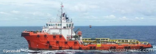
 HERCULES
Current Status
Where is the vessel?
HERCULES is currently in 12 nm N of Suqutrá, based on AIS data received about 1h ago.
Latest AIS update:
Current position: 12.68500° N, 54.06833° E (12 nm N of Suqutrá)
Average speed (last 7 days): Loading…
Average speed (last 30 days): Loading…
Vessel profile: HERCULES is a Offshore Tug/Supply Ship with dimensions 13m x 59m.
This page combines live AIS, route history, probable destination signals, nearby traffic, and port activity for practical vessel monitoring.
The current position of vessel HERCULES is 12.68500 lat / 54.06833 lng. Updated: 2026-04-22 07:54:34 UTCNearest reference points:
- 110 nm NE of Gross Koris
Currently sailing under the flag of Togo ![]()
HERCULES built in 2009 year
Deadweight:
1475 tDetails:
Live Vessel HERCULES Analytics (details, animations, etc.)
Recent AIS points (UTC):
2026-04-22 03:42:33 UTC · 12.68500, 54.06833 · SOG 0 kn · COG -1°2026-04-22 05:48:34 UTC · 12.68500, 54.06833 · SOG 0 kn · COG -1°
2026-04-22 07:06:40 UTC · 12.68500, 54.06833 · SOG 0 kn · COG -1°
2026-04-22 07:54:34 UTC · 12.68500, 54.06833 · SOG 0 kn · COG -1°