 vesseltracker.com
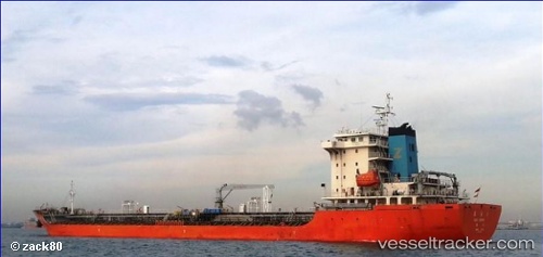
 LOCH LOMOND
Current Status
Where is the vessel?
LOCH LOMOND is currently in Near Tampines, based on AIS data received about 1h ago.
Latest AIS update:
Current position: 1.28375° N, 103.94754° E (Near Tampines)
Average speed (last 7 days): Loading…
Average speed (last 30 days): Loading…
Vessel profile: LOCH LOMOND is a Chemical/Oil Products Tanker with dimensions 150m x 24m.
This page combines live AIS, route history, probable destination signals, nearby traffic, and port activity for practical vessel monitoring.
The current position of vessel LOCH LOMOND is 1.28375 lat / 103.94754 lng. Updated: 2026-04-09 12:15:51 UTCNearest reference points:
- Near Changi
- Near Tampines
- Near Choa Chu Kang
Currently sailing under the flag of Liberia ![]()
LOCH LOMOND built in 2010 year
Deadweight:
19098 tDetails:
Live Vessel LOCH LOMOND Analytics (details, animations, etc.)
Recent AIS points (UTC):
2026-04-09 05:51:43 UTC · 1.28507, 103.95017 · SOG 0 kn · COG 235°2026-04-09 07:48:44 UTC · 1.28490, 103.94820 · SOG 0.1 kn · COG 121°
2026-04-09 09:27:47 UTC · 1.28376, 103.94802 · SOG 0 kn · COG 67°
2026-04-09 12:15:51 UTC · 1.28375, 103.94754 · SOG 0 kn · COG 81°