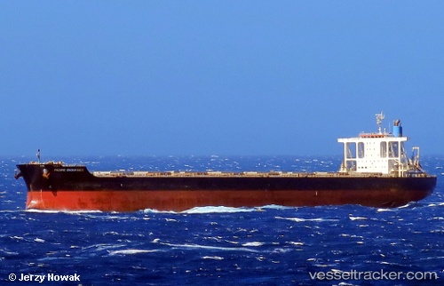
.
Vessel photo of PACIFIST (IMO 9573775) vesseltracker.com

LB flag PACIFIST

Vessel type: Bulk Carrier | IMO: 9573775 | MMSI: MMSI: 636020330
Call sign: D5YS6 | Dimensions: 292 m x 45 m
Current Status

Where is the vessel?

PACIFIST is currently in Open sea, approx. 419 nm off the nearest listed port, based on AIS data received less than 1h ago.

Latest AIS update:

Current position: 31.25330° S, 50.61769° E (Open sea, approx. 419 nm off the nearest listed port)

Average speed (last 7 days): Loading…

Average speed (last 30 days): Loading…

Vessel profile: PACIFIST is a Bulk Carrier with dimensions 292m x 45m.

This page combines live AIS, route history, probable destination signals, nearby traffic, and port activity for practical vessel monitoring.

The current position of vessel PACIFIST is -31.25330 lat / 50.61769 lng. Updated: 2026-04-18 00:23:09 UTC
Nearest reference points:
  • Open sea, approx. 419 nm off the nearest listed port
  • Open sea, approx. 415 nm off the nearest listed port
  • Open sea, approx. 421 nm off the nearest listed port

Currently sailing under the flag of Liberia LB flag

PACIFIST built in 2011 year

Deadweight:
181458 t

Details:

Live Vessel PACIFIST Analytics (details, animations, etc.)


Recent AIS points (UTC):
2026-04-17 17:48:02 UTC · -31.52947, 49.28596 · SOG 10.4 kn · COG 77°
2026-04-17 19:41:31 UTC · -31.46666, 49.66269 · SOG 10.3 kn · COG 77°
2026-04-17 22:23:32 UTC · -31.35925, 50.21136 · SOG 11 kn · COG 73°
2026-04-18 00:23:09 UTC · -31.25330, 50.61769 · SOG 10.7 kn · COG 69°

Track of the vessel in the last 60 days


UTC: --
Start: -- Track timeline (UTC) End: --
Encountered: --


Link to the map:


Find another ship

PACIFIST (636020330) last ports (portcalls and passsages)

PULAU SAMBU | 2025-06-17 06:32:51
TANAH MERAH | 2025-06-15 21:09:46
PENGERANG | 2025-06-15 20:24:06
LANSHAN | 2025-05-30 00:00:36
PENGERANG | 2025-05-20 06:48:14
TANAH MERAH | 2025-05-18 23:04:53
BATU AMPAR | 2025-05-18 20:40:03
PULAU SAMBU | 2025-05-18 18:51:16
Sebang | 2025-05-16 03:56:40
Port Louis | 2025-05-05 10:31:12
PUERTO DE SALINETAS | 2025-04-08 02:08:01
TALIARTE | 2025-04-07 08:14:31
Puerto De La Luz | 2025-04-06 20:01:59
Grand Banks South | 2025-03-30 04:15:27
TANAH MERAH | 2025-01-21 07:54:04
PENGERANG | 2025-01-21 06:32:21
Nantong | 2025-01-11 06:46:13
Wusong | 2025-01-11 01:25:38
Jingjiang | 2025-01-10 20:12:16
PENGERANG | 2024-12-29 06:03:51
TANAH MERAH | 2024-12-29 05:18:07
PULAU SAMBU | 2024-12-29 03:31:36
BUKOM ISLAND | 2024-12-29 02:58:16
Sebang | 2024-12-26 18:23:38
SALDANHA | 2024-12-05 16:46:09
Saldanha Bay | 2024-12-05 13:27:24
Fujairah | 2024-11-19 05:10:23
Ponta Delgada | 2024-09-15 18:25:23
Ijmuiden | 2024-09-02 03:41:43
Ijmuiden | 2024-08-29 02:42:13
Gladstone Harbor | 2024-06-17 04:40:02
Nansha | 2024-05-19 10:06:23
Guangzhou | 2024-05-15 08:34:35
Nansha | 2024-05-15 07:36:17
Sambu | 2024-04-23 00:38:48
Port Louis | 2024-04-09 05:22:18
Sambu | 2024-01-23 17:42:37
Yosu | 2023-11-30 22:58:36
Pohang | 2023-11-21 09:00:13
Pohang | 2023-11-17 08:58:45
Tsugaru-Kaikyo | 2023-11-13 05:41:12
Vancouver | 2023-10-26 23:11:22
Vancouver | 2023-10-22 22:35:24
Victoria | 2023-09-30 18:04:24
Victoria | 2023-08-15 12:32:49
Vancouver | 2023-08-13 00:26:38
Vancouver | 2023-08-08 23:10:19
Prince Rupert | 2023-07-10 19:29:42
Singapore | 2023-06-02 14:58:47
Port Headland | 2023-01-08 14:19:53
Sitrah Anchorage | 2022-08-20 10:50:24
Sitrah Anchorage | 2022-08-10 19:05:12
Nansha | 2022-02-26 06:09:34