 vesseltracker.com
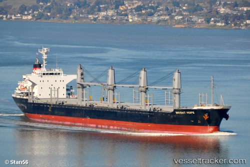
Bright Hope
Current StatusWhere is the vessel?
Bright Hope is currently in Near TABACO, based on AIS data received about 3h ago.
Latest AIS update:
Current position: 13.35097° N, 123.75598° E (Near TABACO)
Average speed (last 7 days): Loading…
Average speed (last 30 days): Loading…
Vessel profile: Bright Hope is a Bulk Carrier with dimensions 27m x 170m.
This page combines live AIS, route history, probable destination signals, nearby traffic, and port activity for practical vessel monitoring.
The current position of vessel Bright Hope is 13.35097 lat / 123.75598 lng. Updated: 2026-04-18 00:39:33 UTCNearest reference points:
- 40 nm N of Gigmoto, Catanduanes
- Near Tacloban
Details:
Live Vessel Bright Hope Analytics (details, animations, etc.)
Recent AIS points (UTC):
2026-04-17 21:42:34 UTC · 13.35100, 123.75618 · SOG 0 kn · COG 226°2026-04-17 23:27:33 UTC · 13.35068, 123.75633 · SOG 0 kn · COG 242°
2026-04-18 00:39:33 UTC · 13.35097, 123.75598 · SOG 0 kn · COG 224°
2026-04-18 00:39:33 UTC · 13.35097, 123.75598 · SOG 0 kn · COG 224°