 vesseltracker.com
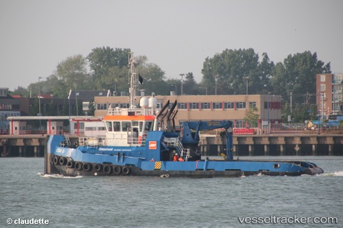
Lydia D
Current StatusWhere is the vessel?
Lydia D is currently in 53 nm W of Sukuta, based on AIS data received about 1h ago.
Latest AIS update:
Current position: 13.71608° N, 17.53867° W (53 nm W of Sukuta)
Average speed (last 7 days): Loading…
Average speed (last 30 days): Loading…
Vessel profile: Lydia D is a Tug with dimensions 10m x 31m.
This page combines live AIS, route history, probable destination signals, nearby traffic, and port activity for practical vessel monitoring.
The current position of vessel Lydia D is 13.71608 lat / -17.53867 lng. Updated: 2026-04-17 23:23:18 UTCNearest reference points:
- Near Rufisque
- Near Dakar
- Near Banjul
Details:
Live Vessel Lydia D Analytics (details, animations, etc.)
Recent AIS points (UTC):
2026-04-17 17:35:28 UTC · 13.72086, -17.52516 · SOG 0.6 kn · COG -1°2026-04-17 19:56:58 UTC · 13.72427, -17.53966 · SOG 0.7 kn · COG -1°
2026-04-17 22:16:58 UTC · 13.71470, -17.53330 · SOG 0.4 kn · COG -1°
2026-04-17 23:23:18 UTC · 13.71608, -17.53867 · SOG 0.4 kn · COG -1°