 vesseltracker.com
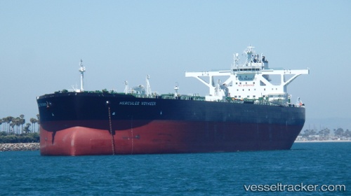
 ALMI HERCULES
Current Status
Where is the vessel?
ALMI HERCULES is currently in Near ONSAN, based on AIS data received about 1h ago.
Latest AIS update:
Current position: 35.43142° N, 129.40213° E (Near ONSAN)
Average speed (last 7 days): Loading…
Average speed (last 30 days): Loading…
Vessel profile: ALMI HERCULES is a Crude Oil Tanker with dimensions 60m x 330m.
This page combines live AIS, route history, probable destination signals, nearby traffic, and port activity for practical vessel monitoring.
The current position of vessel ALMI HERCULES is 35.43142 lat / 129.40213 lng. Updated: 2026-04-06 08:09:55 UTCNearest reference points:
- Near ONSAN
- Near Ulsan
- Near Ilsan
Currently sailing under the flag of Liberia ![]()
ALMI HERCULES built in 2014 year
Deadweight:
319359 tDetails:
Live Vessel ALMI HERCULES Analytics (details, animations, etc.)
Recent AIS points (UTC):
2026-04-06 01:20:32 UTC · 35.43227, 129.39500 · SOG 0 kn · COG 208°2026-04-06 03:50:34 UTC · 35.43227, 129.39503 · SOG 0 kn · COG 208°
2026-04-06 05:53:34 UTC · 35.43261, 129.39301 · SOG 0.1 kn · COG 174°
2026-04-06 08:09:55 UTC · 35.43142, 129.40213 · SOG 4.6 kn · COG 142°