 vesseltracker.com
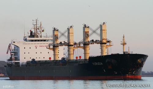
 Veruda
Current Status
Where is the vessel?
Veruda is currently in Near Marina di Ravenna, based on AIS data received less than 1h ago.
Latest AIS update:
Current position: 44.49567° N, 12.49350° E (Near Marina di Ravenna)
Average speed (last 7 days): Loading…
Average speed (last 30 days): Loading…
Vessel profile: Veruda is a Bulk Carrier with dimensions 182m x 32m.
This page combines live AIS, route history, probable destination signals, nearby traffic, and port activity for practical vessel monitoring.
The current position of vessel Veruda is 44.49567 lat / 12.49350 lng. Updated: 2026-04-19 17:44:27 UTCNearest reference points:
- Near Marina di Ravenna
- Near San Giuseppe
- Near Porto San Vitale
Currently sailing under the flag of Croatia ![]()
Veruda built in 2011 year
Deadweight:
51886 tDetails:
Live Vessel Veruda Analytics (details, animations, etc.)
Recent AIS points (UTC):
2026-04-19 13:59:28 UTC · 44.49433, 12.49350 · SOG 0 kn · COG 58°2026-04-19 16:23:29 UTC · 44.49484, 12.49333 · SOG 0 kn · COG 77°
2026-04-19 16:41:28 UTC · 44.49450, 12.49367 · SOG 0 kn · COG 62°
2026-04-19 17:44:27 UTC · 44.49567, 12.49350 · SOG 0 kn · COG 111°