 vesseltracker.com
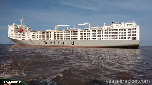
 AL KUWAIT
Current Status
Where is the vessel?
AL KUWAIT is currently in 117 nm W of Palmerston, based on AIS data received about 1h ago.
Latest AIS update:
Current position: 12.20842° S, 128.85590° E (117 nm W of Palmerston)
Average speed (last 7 days): Loading…
Average speed (last 30 days): Loading…
Vessel profile: AL KUWAIT is a Livestock Carrier with dimensions 189m x 189m.
This page combines live AIS, route history, probable destination signals, nearby traffic, and port activity for practical vessel monitoring.
The current position of vessel AL KUWAIT is -12.20842 lat / 128.85590 lng. Updated: 2026-04-18 17:35:40 UTCNearest reference points:
- Near Palmerston
- Near Winnellie
Currently sailing under the flag of Kuwait ![]()
AL KUWAIT built in 2016 year
Deadweight:
16110 tDetails:
Live Vessel AL KUWAIT Analytics (details, animations, etc.)
Recent AIS points (UTC):
2026-04-18 11:48:14 UTC · -12.33865, 130.71262 · SOG 15.5 kn · COG 320°2026-04-18 13:53:14 UTC · -12.19764, 130.05035 · SOG 20 kn · COG 269°
2026-04-18 16:06:57 UTC · -12.20525, 129.31642 · SOG 18.7 kn · COG 269°
2026-04-18 17:35:40 UTC · -12.20842, 128.85590 · SOG 18.1 kn · COG 275°