 vesseltracker.com
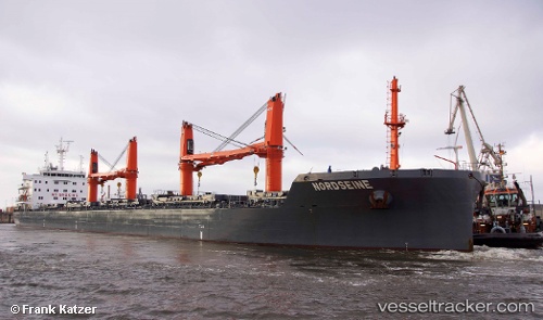
 NORDSEINE
Current Status
Where is the vessel?
NORDSEINE is currently in 143 nm E of Porto Santo Island, based on AIS data received about 1h ago.
Latest AIS update:
Current position: 32.20167° N, 13.68833° W (143 nm E of Porto Santo Island)
Average speed (last 7 days): Loading…
Average speed (last 30 days): Loading…
Vessel profile: NORDSEINE is a Bulk Carrier with dimensions 190m x 29m.
This page combines live AIS, route history, probable destination signals, nearby traffic, and port activity for practical vessel monitoring.
The current position of vessel NORDSEINE is 32.20167 lat / -13.68833 lng. Updated: 2026-04-07 19:34:16 UTCNearest reference points:
- 148 nm SE of Porto Santo Island
- 109 nm E of Porto Santo Island
- 101 nm SW of Jarjis
Currently sailing under the flag of Portugal (MAR) ![]()
NORDSEINE built in 2015 year
Deadweight:
38036 tDetails:
Live Vessel NORDSEINE Analytics (details, animations, etc.)
Recent AIS points (UTC):
2026-04-07 13:16:15 UTC · 33.46667, -13.31833 · SOG 12 kn · COG -1°2026-04-07 15:22:18 UTC · 33.04833, -13.44167 · SOG 12 kn · COG -1°
2026-04-07 17:46:16 UTC · 32.56500, -13.58500 · SOG 12 kn · COG -1°
2026-04-07 19:34:16 UTC · 32.20167, -13.68833 · SOG 12 kn · COG -1°