 vesseltracker.com
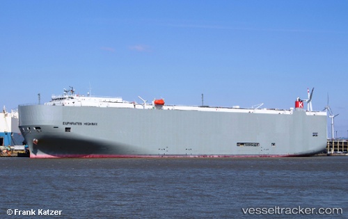
 Euphrates Highway
Current Status
Where is the vessel?
Euphrates Highway is currently in 38 nm E of Corolla, based on AIS data received less than 1h ago.
Latest AIS update:
Current position: 36.57667° N, 75.07608° W (38 nm E of Corolla)
Average speed (last 7 days): Loading…
Average speed (last 30 days): Loading…
Vessel profile: Euphrates Highway is a Vehicles Carrier with dimensions 199m x 199m.
This page combines live AIS, route history, probable destination signals, nearby traffic, and port activity for practical vessel monitoring.
The current position of vessel Euphrates Highway is 36.57667 lat / -75.07608 lng. Updated: 2026-04-18 16:19:09 UTCNearest reference points:
- 26 nm E of Corolla
- 45 nm NE of Nags Head
- 48 nm E of Nags Head
Currently sailing under the flag of Panama ![]()
Euphrates Highway built in 2012 year
Deadweight:
18668 tDetails:
Live Vessel Euphrates Highway Analytics (details, animations, etc.)
Recent AIS points (UTC):
2026-04-18 09:22:49 UTC · 36.56775, -74.69279 · SOG 0.3 kn · COG 194°2026-04-18 12:27:31 UTC · 36.55739, -74.71502 · SOG 0.6 kn · COG 248°
2026-04-18 13:40:44 UTC · 36.55116, -74.72836 · SOG 0.5 kn · COG 199°
2026-04-18 16:19:09 UTC · 36.57667, -75.07608 · SOG 8.9 kn · COG 279°