 vesseltracker.com
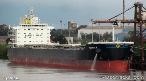
 George P
Current Status
Where is the vessel?
George P is currently in 141 nm SW of Akpo, based on AIS data received less than 1h ago.
Latest AIS update:
Current position: 4.96417° S, 59.35267° E (141 nm SW of Akpo)
Average speed (last 7 days): Loading…
Average speed (last 30 days): Loading…
Vessel profile: George P is a Bulk Carrier with dimensions 229m x 32m.
This page combines live AIS, route history, probable destination signals, nearby traffic, and port activity for practical vessel monitoring.
The current position of vessel George P is -4.96417 lat / 59.35267 lng. Updated: 2026-04-06 13:26:38 UTCNearest reference points:
- 104 nm S of Akpo
Currently sailing under the flag of Marshall Is ![]()
George P built in 2012 year
Deadweight:
81569 tDetails:
Live Vessel George P Analytics (details, animations, etc.)
Recent AIS points (UTC):
2026-04-06 08:00:53 UTC · -5.44217, 58.50350 · SOG 10.9 kn · COG 58°2026-04-06 09:54:13 UTC · -5.27867, 58.79600 · SOG 10.3 kn · COG 54°
2026-04-06 11:30:23 UTC · -5.13200, 59.03833 · SOG 10.9 kn · COG 59°
2026-04-06 13:26:38 UTC · -4.96417, 59.35267 · SOG 11.1 kn · COG 60°