 vesseltracker.com
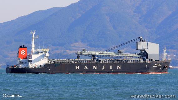
 HANJIN GREEN
Current Status
Where is the vessel?
HANJIN GREEN is currently in Near Sangam-dong, based on AIS data received about 2h ago.
Latest AIS update:
Current position: 34.86155° N, 127.74388° E (Near Sangam-dong)
Average speed (last 7 days): Loading…
Average speed (last 30 days): Loading…
Vessel profile: HANJIN GREEN is a General Cargo Ship with dimensions 24m x 109m.
This page combines live AIS, route history, probable destination signals, nearby traffic, and port activity for practical vessel monitoring.
The current position of vessel HANJIN GREEN is 34.86155 lat / 127.74388 lng. Updated: 2026-04-18 07:52:41 UTCNearest reference points:
- Near Sangam-dong
- Near Gwangyang
- Near Boseong-gun
Currently sailing under the flag of Korea (Republic of) ![]()
HANJIN GREEN built in 2011 year
Deadweight:
10376 tDetails:
Live Vessel HANJIN GREEN Analytics (details, animations, etc.)
Recent AIS points (UTC):
2026-04-18 01:36:50 UTC · 34.86152, 127.74387 · SOG 0 kn · COG 270°2026-04-18 03:52:25 UTC · 34.86152, 127.74390 · SOG 0 kn · COG 270°
2026-04-18 05:34:31 UTC · 34.86153, 127.74392 · SOG 0 kn · COG 270°
2026-04-18 07:52:41 UTC · 34.86155, 127.74388 · SOG 0 kn · COG 270°