 vesseltracker.com
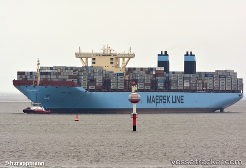
 MARY MAERSK
Current Status
Where is the vessel?
MARY MAERSK is currently in Near Bremerhaven-Speckenbüttel, based on AIS data received less than 1h ago.
Latest AIS update:
Current position: 53.59900° N, 8.51380° E (Near Bremerhaven-Speckenbüttel)
Average speed (last 7 days): Loading…
Average speed (last 30 days): Loading…
Vessel profile: MARY MAERSK is a Container Ship with dimensions 399m x 59m.
This page combines live AIS, route history, probable destination signals, nearby traffic, and port activity for practical vessel monitoring.
The current position of vessel MARY MAERSK is 53.59900 lat / 8.51380 lng. Updated: 2026-04-03 03:23:55 UTCNearest reference points:
- Near Bremerhaven
- Near Sandstedt
- Near Brake
Currently sailing under the flag of Denmark ![]()
MARY MAERSK built in 2013 year
Deadweight:
213970 tDetails:
Live Vessel MARY MAERSK Analytics (details, animations, etc.)
Recent AIS points (UTC):
2026-04-02 21:45:20 UTC · 53.59903, 8.51380 · SOG 0 kn · COG -1°2026-04-03 00:05:56 UTC · 53.59902, 8.51380 · SOG 0 kn · COG 321°
2026-04-03 02:14:55 UTC · 53.59900, 8.51378 · SOG 0 kn · COG 321°
2026-04-03 03:23:55 UTC · 53.59900, 8.51380 · SOG 0 kn · COG 321°