 vesseltracker.com
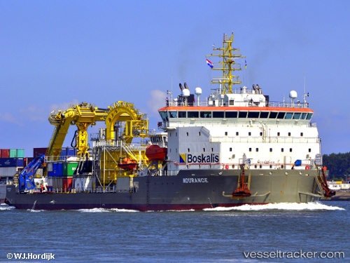
 Ndurance
Current Status
Where is the vessel?
Ndurance is currently in Near Rotterdam, based on AIS data received less than 1h ago.
Latest AIS update:
Current position: 51.89088° N, 4.45073° E (Near Rotterdam)
Average speed (last 7 days): Loading…
Average speed (last 30 days): Loading…
Vessel profile: Ndurance is a Cable Layer with dimensions 99m x 30m.
This page combines live AIS, route history, probable destination signals, nearby traffic, and port activity for practical vessel monitoring.
The current position of vessel Ndurance is 51.89088 lat / 4.45073 lng. Updated: 2026-04-07 06:17:06 UTCNearest reference points:
- Near Rotterdam
- Near ROTTERDAM WAALHAVEN
- Near DELFSHAVEN
Currently sailing under the flag of Cyprus ![]()
Ndurance built in 2013 year
Deadweight:
12287 tDetails:
Live Vessel Ndurance Analytics (details, animations, etc.)
Recent AIS points (UTC):
2026-04-06 23:29:04 UTC · 51.89089, 4.45074 · SOG 0 kn · COG 285°2026-04-07 01:26:49 UTC · 51.89085, 4.45072 · SOG 0 kn · COG -1°
2026-04-07 04:17:00 UTC · 51.89092, 4.45071 · SOG 0 kn · COG 285°
2026-04-07 06:17:06 UTC · 51.89088, 4.45073 · SOG 0 kn · COG 285°