 vesseltracker.com
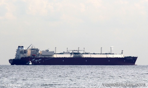
 WOODSIDE GOODE
Current Status
Where is the vessel?
WOODSIDE GOODE is currently in 34 nm W of Wainibe, based on AIS data received about 2h ago.
Latest AIS update:
Current position: 2.87158° S, 125.99633° E (34 nm W of Wainibe)
Average speed (last 7 days): Loading…
Average speed (last 30 days): Loading…
Vessel profile: WOODSIDE GOODE is a Lng Tanker with dimensions m x m.
This page combines live AIS, route history, probable destination signals, nearby traffic, and port activity for practical vessel monitoring.
The current position of vessel WOODSIDE GOODE is -2.87158 lat / 125.99633 lng. Updated: 2026-04-12 13:03:58 UTCNearest reference points:
- 69 nm NW of Wainibe
- 55 nm S of Labuha, Molucas
- Near Ambon
Currently sailing under the flag of Liberia ![]()
Details:
Live Vessel WOODSIDE GOODE Analytics (details, animations, etc.)
Recent AIS points (UTC):
2026-04-12 07:11:40 UTC · -2.48143, 126.49439 · SOG 6.6 kn · COG 205°2026-04-12 09:15:49 UTC · -2.63093, 126.33272 · SOG 6.5 kn · COG 250°
2026-04-12 11:39:12 UTC · -2.77767, 126.11393 · SOG 6.8 kn · COG 233°
2026-04-12 13:03:58 UTC · -2.87158, 125.99633 · SOG 6.3 kn · COG 226°