 vesseltracker.com
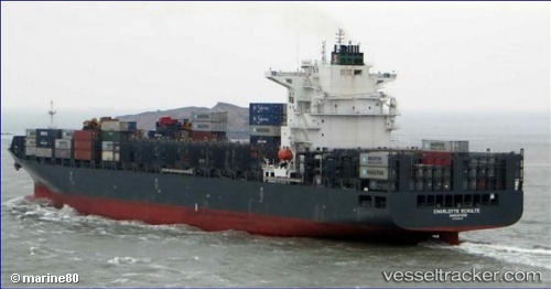
 Charlotte Schulte
Current Status
Where is the vessel?
Charlotte Schulte is currently in 26 nm W of Keti Bandar, based on AIS data received less than 1h ago.
Latest AIS update:
Current position: 24.20487° N, 66.97068° E (26 nm W of Keti Bandar)
Average speed (last 7 days): Loading…
Average speed (last 30 days): Loading…
Vessel profile: Charlotte Schulte is a Container Ship with dimensions 255m x 37m.
This page combines live AIS, route history, probable destination signals, nearby traffic, and port activity for practical vessel monitoring.
The current position of vessel Charlotte Schulte is 24.20487 lat / 66.97068 lng. Updated: 2026-03-29 05:13:48 UTCNearest reference points:
- 16 nm S of Kiamari
- Near Kiamari
- Near PORT QASIM
Currently sailing under the flag of Singapore ![]()
Charlotte Schulte built in 2014 year
Deadweight:
65128 tDetails:
Live Vessel Charlotte Schulte Analytics (details, animations, etc.)
Recent AIS points (UTC):
2026-03-28 23:30:33 UTC · 24.76380, 67.32301 · SOG 0.1 kn · COG -1°2026-03-29 00:53:33 UTC · 24.78317, 67.28511 · SOG 7.3 kn · COG 300°
2026-03-29 03:42:34 UTC · 24.51623, 67.04029 · SOG 12.7 kn · COG 206°
2026-03-29 05:13:48 UTC · 24.20487, 66.97068 · SOG 12.6 kn · COG -1°