 vesseltracker.com
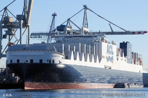
 ATLANTIC SKY
Current Status
Where is the vessel?
ATLANTIC SKY is currently in Near Dartmouth, based on AIS data received about 2h ago.
Latest AIS update:
Current position: 44.66750° N, 63.62780° W (Near Dartmouth)
Average speed (last 7 days): Loading…
Average speed (last 30 days): Loading…
Vessel profile: ATLANTIC SKY is a Container Ro-Ro Cargo Ship with dimensions 296m x 37m.
This page combines live AIS, route history, probable destination signals, nearby traffic, and port activity for practical vessel monitoring.
The current position of vessel ATLANTIC SKY is 44.6675 lat / -63.6278 lng. Updated: 2026-04-08 19:58:48 UTCNearest reference points:
- Near Halifax
- Near Eastern Passage
- 20 nm S of Head of Jeddore
Currently sailing under the flag of Malta ![]()
ATLANTIC SKY built in 2017 year
Deadweight:
55828 tDetails:
Live Vessel ATLANTIC SKY Analytics (details, animations, etc.)
Recent AIS points (UTC):
2026-04-08 13:53:35 UTC · 44.52330, -62.11330 · SOG 17 kn · COG -1°2026-04-08 15:26:54 UTC · 44.48590, -62.73880 · SOG 17 kn · COG -1°
2026-04-08 18:06:28 UTC · 44.52520, -63.51060 · SOG 10.3 kn · COG 324°
2026-04-08 19:58:48 UTC · 44.66750, -63.62780 · SOG 0 kn · COG 22°