 vesseltracker.com
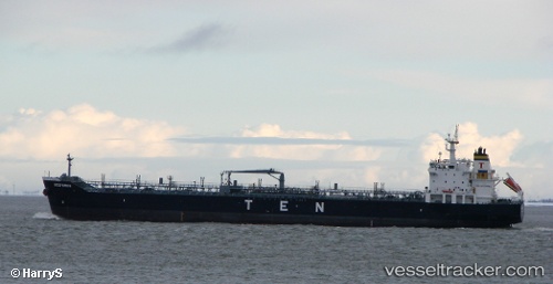
 BOSPORUS
Current Status
Where is the vessel?
BOSPORUS is currently in 10 nm SE of ILHA GUAIBA, based on AIS data received about 2h ago.
Latest AIS update:
Current position: 23.14525° S, 43.91754° W (10 nm SE of ILHA GUAIBA)
Average speed (last 7 days): Loading…
Average speed (last 30 days): Loading…
Vessel profile: BOSPORUS is a Cargo with dimensions m x m.
This page combines live AIS, route history, probable destination signals, nearby traffic, and port activity for practical vessel monitoring.
The current position of vessel BOSPORUS is -23.14525 lat / -43.91754 lng. Updated: 2026-04-06 11:38:58 UTCNearest reference points:
- Near ILHA GUAIBA
- Near SANTA RITA
- Near CUNHAMBEBE
Currently sailing under the flag of Liberia ![]()
Details:
Live Vessel BOSPORUS Analytics (details, animations, etc.)
Recent AIS points (UTC):
2026-04-06 05:44:56 UTC · -23.14260, -43.92079 · SOG 0.1 kn · COG 177°2026-04-06 07:48:02 UTC · -23.14467, -43.91778 · SOG 0.2 kn · COG 262°
2026-04-06 09:56:59 UTC · -23.14547, -43.91761 · SOG 0 kn · COG 286°
2026-04-06 11:38:58 UTC · -23.14525, -43.91754 · SOG 0 kn · COG 281°