 vesseltracker.com
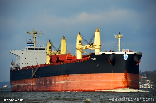
 ANANI
ANANI
Current Status
Where is the vessel?
ANANI is currently in Near Acajutla, based on AIS data received about 1h ago.
Latest AIS update:
Current position: 13.57848° N, 89.89862° W (Near Acajutla)
Average speed (last 7 days): Loading…
Average speed (last 30 days): Loading…
Vessel profile: ANANI is a Bulk Carrier with dimensions 32m x 200m.
This page combines live AIS, route history, probable destination signals, nearby traffic, and port activity for practical vessel monitoring.
The current position of vessel ANANI is 13.57848 lat / -89.89862 lng. Updated: 2026-04-13 11:39:50 UTCNearest reference points:
- Near San Jose
- Near El Salvador
- 14 nm NW of Puerto Cortes
Currently sailing under the flag of Singapore ![]()
ANANI built in 2015 year
Deadweight:
61631 tDetails:
Live Vessel ANANI Analytics (details, animations, etc.)
Recent AIS points (UTC):
2026-04-13 05:57:49 UTC · 13.58025, -89.89810 · SOG 0.1 kn · COG 111°2026-04-13 07:36:49 UTC · 13.57996, -89.89844 · SOG 0.1 kn · COG 109°
2026-04-13 10:06:49 UTC · 13.57974, -89.89866 · SOG 0.1 kn · COG 105°
2026-04-13 11:39:50 UTC · 13.57848, -89.89862 · SOG 0.3 kn · COG 74°