 vesseltracker.com
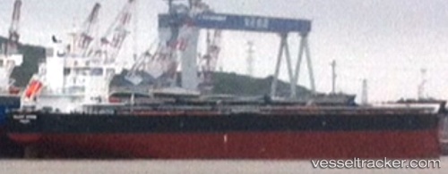
 VELA
VELA
Current Status
Where is the vessel?
VELA is currently in 262 nm SW of Punta Baja, based on AIS data received about 2h ago.
Latest AIS update:
Current position: 27.87812° N, 120.18784° W (262 nm SW of Punta Baja)
Average speed (last 7 days): Loading…
Average speed (last 30 days): Loading…
Vessel profile: VELA is a Cargo with dimensions m x m.
This page combines live AIS, route history, probable destination signals, nearby traffic, and port activity for practical vessel monitoring.
The current position of vessel VELA is 27.87812 lat / -120.18784 lng. Updated: 2026-04-17 04:20:33 UTCNearest reference points:
- Open sea, approx. 405 nm off the nearest listed port
- Open sea, approx. 401 nm off the nearest listed port
- Open sea, approx. 409 nm off the nearest listed port
Currently sailing under the flag of Marshall Islands ![]()
Details:
Live Vessel VELA Analytics (details, animations, etc.)
Recent AIS points (UTC):
2026-04-16 21:51:24 UTC · 28.98167, -121.04833 · SOG 12 kn · COG -1°2026-04-17 00:03:53 UTC · 28.59458, -120.76046 · SOG 12.7 kn · COG 141°
2026-04-17 01:35:53 UTC · 28.32943, -120.55444 · SOG 12.2 kn · COG 140°
2026-04-17 04:20:33 UTC · 27.87812, -120.18784 · SOG 11.9 kn · COG 144°