 vesseltracker.com
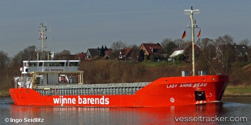
 Lady Anne Beau
Current Status
Where is the vessel?
Lady Anne Beau is currently in Near Rotterdam, based on AIS data received less than 1h ago.
Latest AIS update:
Current position: 51.89129° N, 4.45381° E (Near Rotterdam)
Average speed (last 7 days): Loading…
Average speed (last 30 days): Loading…
Vessel profile: Lady Anne Beau is a General Cargo Ship with dimensions 88m x 14m.
This page combines live AIS, route history, probable destination signals, nearby traffic, and port activity for practical vessel monitoring.
The current position of vessel Lady Anne Beau is 51.89129 lat / 4.45381 lng. Updated: 2026-04-12 21:29:30 UTCNearest reference points:
- Near Rotterdam
- Near ROTTERDAM WAALHAVEN
- Near DELFSHAVEN
Currently sailing under the flag of Netherlands ![]()
Details:
Live Vessel Lady Anne Beau Analytics (details, animations, etc.)
Recent AIS points (UTC):
2026-04-12 15:29:34 UTC · 51.89129, 4.45386 · SOG 0 kn · COG 104°2026-04-12 17:45:13 UTC · 51.89132, 4.45387 · SOG 0 kn · COG -1°
2026-04-12 19:50:35 UTC · 51.89130, 4.45383 · SOG 0 kn · COG 104°
2026-04-12 21:29:30 UTC · 51.89129, 4.45381 · SOG 0 kn · COG 104°