 vesseltracker.com
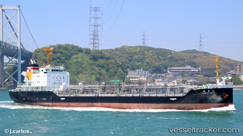
 Kinryu Maru
Current Status
Where is the vessel?
Kinryu Maru is currently in Near Yokkaichi, based on AIS data received less than 1h ago.
Latest AIS update:
Current position: 34.95304° N, 136.75752° E (Near Yokkaichi)
Average speed (last 7 days): Loading…
Average speed (last 30 days): Loading…
Vessel profile: Kinryu Maru is a Chemical Oil Products Tanker with dimensions 105m x 16m.
This page combines live AIS, route history, probable destination signals, nearby traffic, and port activity for practical vessel monitoring.
The current position of vessel Kinryu Maru is 34.95304 lat / 136.75752 lng. Updated: 2026-04-12 21:55:02 UTCNearest reference points:
- Near Yokkaichi
- Near Nagoya
- Near Kinuura
Currently sailing under the flag of Japan ![]()
Details:
Live Vessel Kinryu Maru Analytics (details, animations, etc.)
Recent AIS points (UTC):
2026-04-12 15:39:04 UTC · 34.54855, 137.76404 · SOG 12.2 kn · COG 268°2026-04-12 17:43:54 UTC · 34.54821, 137.23804 · SOG 12.7 kn · COG 270°
2026-04-12 19:26:24 UTC · 34.66847, 136.86438 · SOG 12.6 kn · COG 311°
2026-04-12 21:55:02 UTC · 34.95304, 136.75752 · SOG 0 kn · COG 14°