 vesseltracker.com
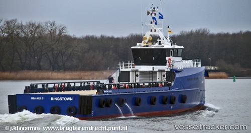
 SEA AXE 51
Current Status
Where is the vessel?
SEA AXE 51 is currently in Near El Chaure, based on AIS data received less than 1h ago.
Latest AIS update:
Current position: 10.24059° N, 64.63316° W (Near El Chaure)
Average speed (last 7 days): Loading…
Average speed (last 30 days): Loading…
Vessel profile: SEA AXE 51 is a High speed craft with dimensions m x m.
This page combines live AIS, route history, probable destination signals, nearby traffic, and port activity for practical vessel monitoring.
The current position of vessel SEA AXE 51 is 10.24059 lat / -64.63316 lng. Updated: 2026-04-03 22:02:29 UTCNearest reference points:
- Near Puerto Sucre
- 15 nm SW of Punta de Piedras
Currently sailing under the flag of Saint Vincent and the Grenadines ![]()
Details:
Live Vessel SEA AXE 51 Analytics (details, animations, etc.)
Recent AIS points (UTC):
2026-04-03 16:04:35 UTC · 10.18437, -64.76973 · SOG 9.9 kn · COG -1°2026-04-03 17:38:33 UTC · 10.24055, -64.63320 · SOG 0.2 kn · COG -1°
2026-04-03 20:14:32 UTC · 10.24052, -64.63320 · SOG 0.1 kn · COG -1°
2026-04-03 22:02:29 UTC · 10.24059, -64.63316 · SOG 0.1 kn · COG -1°