 vesseltracker.com
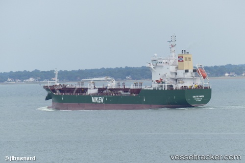
 Skuteviken
Current Status
Where is the vessel?
Skuteviken is currently in Near Donges, based on AIS data received less than 1h ago.
Latest AIS update:
Current position: 47.30464° N, 2.06970° W (Near Donges)
Average speed (last 7 days): Loading…
Average speed (last 30 days): Loading…
Vessel profile: Skuteviken is a Chemical Tanker with dimensions 130m x 20m.
This page combines live AIS, route history, probable destination signals, nearby traffic, and port activity for practical vessel monitoring.
The current position of vessel Skuteviken is 47.30464 lat / -2.06970 lng. Updated: 2026-04-18 15:23:09 UTCNearest reference points:
- Near Arzal
- Near Camoël
- Near LA BARRE DE MONTS
Currently sailing under the flag of France ![]()
Details:
Live Vessel Skuteviken Analytics (details, animations, etc.)
Recent AIS points (UTC):
2026-04-18 09:26:08 UTC · 47.30465, -2.06972 · SOG 0.1 kn · COG 68°2026-04-18 11:35:14 UTC · 47.30464, -2.06970 · SOG 0 kn · COG 68°
2026-04-18 13:26:12 UTC · 47.30466, -2.06970 · SOG 0 kn · COG 68°
2026-04-18 15:23:09 UTC · 47.30464, -2.06970 · SOG 0 kn · COG 68°