 vesseltracker.com
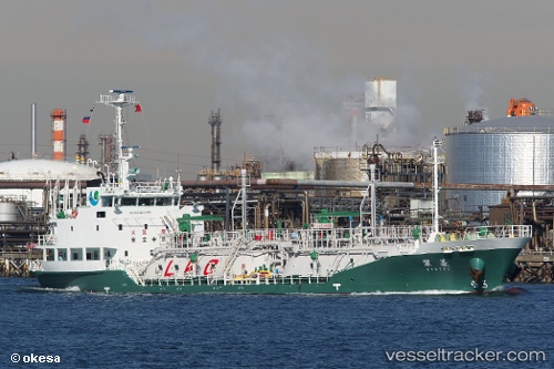
 Ryosui
Current Status
Where is the vessel?
Ryosui is currently in 25 nm NE of Nishitokyo, based on AIS data received about 1h ago.
Latest AIS update:
Current position: 34.90643° N, 139.98549° E (25 nm NE of Nishitokyo)
Average speed (last 7 days): Loading…
Average speed (last 30 days): Loading…
Vessel profile: Ryosui is a Lpg Tanker with dimensions 67m x 12m.
This page combines live AIS, route history, probable destination signals, nearby traffic, and port activity for practical vessel monitoring.
The current position of vessel Ryosui is 34.90643 lat / 139.98549 lng. Updated: 2026-04-22 13:40:53 UTCNearest reference points:
- 15 nm S of Zushi
- Near OHARA
- Near Yokosuka
Currently sailing under the flag of Japan ![]()
Details:
Live Vessel Ryosui Analytics (details, animations, etc.)
Recent AIS points (UTC):
2026-04-22 09:53:44 UTC · 35.41404, 139.72736 · SOG 11.3 kn · COG 232°2026-04-22 10:30:45 UTC · 35.30607, 139.73035 · SOG 11.5 kn · COG 147°
2026-04-22 12:14:55 UTC · 34.98707, 139.72691 · SOG 11.6 kn · COG 184°
2026-04-22 13:40:53 UTC · 34.90643, 139.98549 · SOG 12.3 kn · COG 59°