 vesseltracker.com
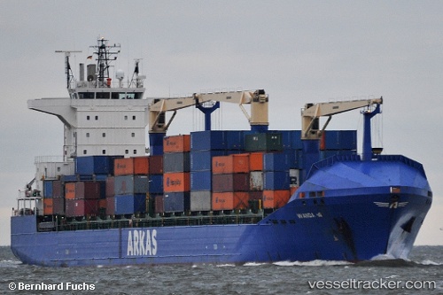
Vessel WANDA A IMO: 9415947, MMSI: 229111000 Container Ship
UTC, 6.35673, 3.30931, course: 260, speed: 0
UTC, 6.35689, 3.30919, course: 250, speed: 0.1
2026-03-04 22:19:42 UTC, 6.35711, 3.30917, course: 248, speed: 0.3
Live Vessel WANDA A Analytics (details, animations, etc.)
Live AIS position: UTC. Near Kirikiri), updated 2026-03-04 22:19:42 UTC.Find the position of the vessel WANDA A on the map. The latter are known coordinates and path.
marine traffic ship tracker show on live map
The current position of vessel WANDA A is 6.35711 lat / 3.30917 lng. Updated: 2026-03-04 22:19:42 UTCCurrently sailing under the flag of Malta
WANDA A built in 2009 year
Deadweight:
21990 tDetails:
Last coordinates of the vessel:
UTC, 6.35674, 3.30928, course: -1, speed: 0.4UTC, 6.35673, 3.30931, course: 260, speed: 0
UTC, 6.35689, 3.30919, course: 250, speed: 0.1
2026-03-04 22:19:42 UTC, 6.35711, 3.30917, course: 248, speed: 0.3