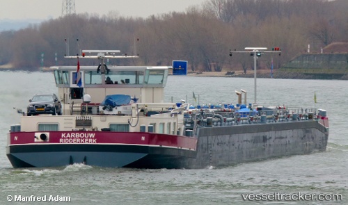
 Karbouw
Current Status
Where is the vessel?
Karbouw is currently in Near Niederkassel, based on AIS data received about 15h ago.
Latest AIS update:
Current position: 50.80469° N, 7.02840° E (Near Niederkassel)
Average speed (last 7 days): Loading…
Average speed (last 30 days): Loading…
Vessel profile: Karbouw is a Other Tanker with dimensions 110m x 12m.
This page combines live AIS, route history, probable destination signals, nearby traffic, and port activity for practical vessel monitoring.
The current position of vessel Karbouw is 50.80469 lat / 7.02840 lng. Updated: 2026-07-04 20:00:05 UTCNearest reference points:
- Near LULSDORF
- Near Ehrenfeld
- Near NEUSS
Currently sailing under the flag of Netherlands ![]()
Details:
Live Vessel Karbouw Analytics (details, animations, etc.)
Recent AIS points (UTC):
2026-07-04 16:01:06 UTC · 51.04130, 6.94774 · SOG 5.1 kn · COG 127°2026-07-04 17:49:44 UTC · 50.91014, 6.97738 · SOG 4.7 kn · COG 154°
2026-07-04 19:38:15 UTC · 50.82483, 7.00383 · SOG 4.8 kn · COG 97°
2026-07-04 20:00:05 UTC · 50.80469, 7.02840 · SOG 5.1 kn · COG 183°