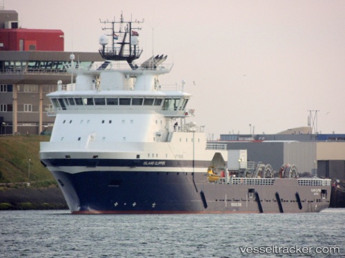
.

Port Vigdis

Where is the Port?
VIGDIS is located near the monitored sea lanes. The official UN/LOCODE of this port is XZVGD.

How many vessels are in Vigdis port?
There are currently 15 vessels in port and 7 vessels recently departed.

Port map updates in near real-time from AIS snapshots and route transitions. Use the vessel-type filters and names toggle in the map control.

NO flag Island Clipper

Vessel type: Offshore Tug Supply Ship | IMO: 9722871 | MMSI: MMSI: 257346000
Call sign: LDNW | Dimensions: 97 m x 20 m
Current Status

Where is the vessel?

Island Clipper is currently in Near Vigdis, based on AIS data received about 15h ago.

Latest AIS update:

Current position: 61.35595° N, 2.23602° E (Near Vigdis)

Average speed (last 7 days): Loading…

Average speed (last 30 days): Loading…

Vessel profile: Island Clipper is a Offshore Tug Supply Ship with dimensions 97m x 20m.

This page combines live AIS, route history, probable destination signals, nearby traffic, and port activity for practical vessel monitoring.

The current position of vessel Island Clipper is 61.35595 lat / 2.23602 lng. Updated: 2026-06-22 16:04:31 UTC
More recent position available: 36 min ago
Free positions are delayed by 14 hours.

We recommend registering. If you register, paid vessel access will be saved in your profile. Guest access works only through a personal link.

Nearest reference points:
  • 10 nm N of Leadon

Currently sailing under the flag of Norway NO flag

Details:

Live Vessel Island Clipper Analytics (details, animations, etc.)


Recent AIS points (UTC):
2026-06-22 13:44:40 UTC · 61.30665, 2.26112 · SOG 0.3 kn · COG 344°
2026-06-22 14:17:41 UTC · 61.30688, 2.26096 · SOG 0.7 kn · COG 346°
2026-06-22 15:55:11 UTC · 61.35583, 2.23575 · SOG 1 kn · COG 319°
2026-06-22 16:04:31 UTC · 61.35595, 2.23602 · SOG 0.5 kn · COG 321°

Track of the vessel in the last 60 days


Most frequent incoming origins

Visund · 1

Most frequent outgoing destinations

Visund · 1


You can see routes between ports on port-to-port analytics.


Link to the map:


Find another ship

Recent vessel arrivals at the port

Latest available transitions/port-call records (UTC). Total: 7
2025-09-15 12:41 UTC · NO flagHavila-Charisma
IMO: 9631890, MMSI: 257419000 | Type: Offshore Tug Supply Ship
2025-09-15 12:41 UTC · NO flag
IMO: 0, MMSI: 992576007 | Type:
2025-09-08 21:59 UTC · NO flagNorth-Pomor
IMO: 9643465, MMSI: 258895000 | Type: Offshore Tug Supply Ship
2025-09-08 15:42 UTC · NI flagSIRI KNUTSEN
IMO: 9247168, MMSI: 257562000 | Type: Crude Oil Tanker
2025-09-06 00:52 UTC · Island-Wellserver
IMO: 9372755, MMSI: 257202000 | Type: Well Stimulation Vessel
2025-09-06 00:52 UTC · NO flag
IMO: 0, MMSI: 992576007 | Type:
2025-09-06 00:52 UTC · NO flagHavila-Charisma
IMO: 9631890, MMSI: 257419000 | Type: Offshore Tug Supply Ship

Recent vessel departures from the port

Latest available transitions/port-call records (UTC). Total: 7
2025-09-15 12:41 UTC · NO flagHavila-Charisma
IMO: 9631890, MMSI: 257419000 | Type: Offshore Tug Supply Ship
2025-09-15 12:41 UTC · NO flag
IMO: 0, MMSI: 992576007 | Type:
2025-09-08 21:59 UTC · NO flagNorth-Pomor
IMO: 9643465, MMSI: 258895000 | Type: Offshore Tug Supply Ship
2025-09-08 15:42 UTC · NI flagSIRI KNUTSEN
IMO: 9247168, MMSI: 257562000 | Type: Crude Oil Tanker
2025-09-06 00:52 UTC · Island-Wellserver
IMO: 9372755, MMSI: 257202000 | Type: Well Stimulation Vessel
2025-09-06 00:52 UTC · NO flag
IMO: 0, MMSI: 992576007 | Type:
2025-09-06 00:52 UTC · NO flagHavila-Charisma
IMO: 9631890, MMSI: 257419000 | Type: Offshore Tug Supply Ship

Shipping companies (lines) whose ships most often called at the port Vigdis:

No companies linked yet.

Port summary

Port congestion score

Loading congestion data…

Vessel type distribution for the last 3 months:

Navigation Aid · 10 calls (83.3%)
Offshore Tug Supply Ship · 1 calls (8.3%)
Unknown · 1 calls (8.3%)

Most frequent incoming origins

Visund · 1

Most frequent outgoing destinations

Visund · 1

Vessels currently in port

Detected by latest AIS in the extended port area, latest 72 hours (deduplicated by vessel).

NO flagIsland-Clipper
Type: Offshore Tug Supply Ship | IMO: 9722871, MMSI: 257346000 | AIS: 2026-06-23 00:28:21 UTC
NO flagHYWIND TAMPEN HY03
Type: Navigation Aid | IMO: 0, MMSI: 992581020 | AIS: 2026-06-23 00:28:15 UTC
NO flagHYWIND TAMPEN HY04
Type: Navigation Aid | IMO: 0, MMSI: 992581021 | AIS: 2026-06-23 00:28:08 UTC
NO flagHYWIND TAMPEN HY02
Type: Navigation Aid | IMO: 0, MMSI: 992581019 | AIS: 2026-06-23 00:28:05 UTC
NO flagHYWIND TAMPEN HY05
Type: Navigation Aid | IMO: 0, MMSI: 992581022 | AIS: 2026-06-23 00:27:12 UTC
NO flag
Type: Unknown | IMO: 0, MMSI: 992576007 | AIS: 2026-06-23 00:27:01 UTC
NO flag
Type: Unknown | IMO: 0, MMSI: 992576008 | AIS: 2026-06-23 00:26:46 UTC
MH flagSEACOSCO YANGTZE
Type: ABS | IMO: 9659373, MMSI: 538007873 | AIS: 2026-06-23 00:26:37 UTC
NO flagHYWIND TAMPEN HY08
Type: Navigation Aid | IMO: 0, MMSI: 992581025 | AIS: 2026-06-23 00:25:21 UTC
NO flagHYWIND TAMPEN HY10
Type: Navigation Aid | IMO: 0, MMSI: 992581027 | AIS: 2026-06-23 00:07:41 UTC
NO flagHYWIND TAMPEN HY09
Type: Navigation Aid | IMO: 0, MMSI: 992581026 | AIS: 2026-06-22 23:57:04 UTC
NO flagHYWIND TAMPEN HY01
Type: Navigation Aid | IMO: 0, MMSI: 992581018 | AIS: 2026-06-22 23:48:56 UTC
NO flagHYWIND TAMPEN HY07
Type: Navigation Aid | IMO: 0, MMSI: 992581024 | AIS: 2026-06-22 23:44:30 UTC
NO flagHYWIND TAMPEN HY11
Type: Navigation Aid | IMO: 0, MMSI: 992581028 | AIS: 2026-06-22 23:41:38 UTC
NO flagHYWIND TAMPEN HY06
Type: Navigation Aid | IMO: 0, MMSI: 992581023 | AIS: 2026-06-20 18:20:38 UTC

Expected arrivals

Forecast from transitions and inferred destination signals.


Port in news

Mentions from Topos news feed and spotlights.