 vesseltracker.com
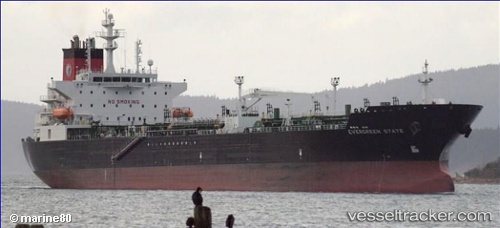
 Evergreen State
Current Status
Where is the vessel?
Evergreen State is currently in 67 nm SW of Port Royal, based on AIS data received about 1h ago.
Latest AIS update:
Current position: 31.63534° N, 78.17760° W (67 nm SW of Port Royal)
Average speed (last 7 days): Loading…
Average speed (last 30 days): Loading…
Vessel profile: Evergreen State is a Chemical Oil Products Tanker with dimensions 183m x 32m.
This page combines live AIS, route history, probable destination signals, nearby traffic, and port activity for practical vessel monitoring.
The current position of vessel Evergreen State is 31.63534 lat / -78.17760 lng. Updated: 2026-05-17 01:57:14 UTCNearest reference points:
- 33 nm S of Kiawah Island
- Near Charleston
- Near North Myrtle Beach
Currently sailing under the flag of USA ![]()
Evergreen State built in 2010 year
Deadweight:
48641 tDetails:
Live Vessel Evergreen State Analytics (details, animations, etc.)
Recent AIS points (UTC):
2026-05-16 22:17:09 UTC · 31.00560, -78.76103 · SOG 14 kn · COG 40°2026-05-16 23:45:28 UTC · 31.26849, -78.50356 · SOG 13.5 kn · COG 30°
2026-05-17 01:57:14 UTC · 31.63534, -78.17760 · SOG 11.9 kn · COG 41°
2026-05-17 01:57:14 UTC · 31.63534, -78.17760 · SOG 11.9 kn · COG 41°