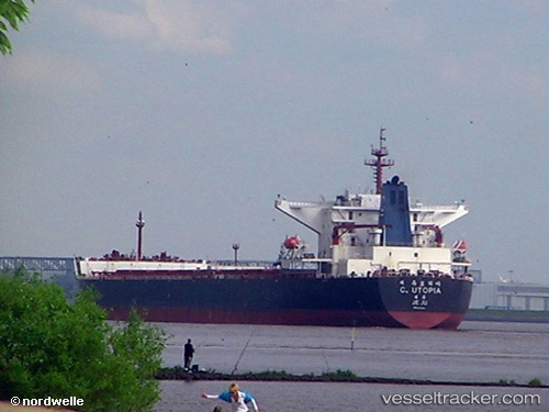
.
Vessel photo of C. UTOPIA (IMO 9344461) vesseltracker.com

MH flag C. UTOPIA

Vessel type: Bulk Carrier | IMO: 9344461 | MMSI: MMSI: 538009813
Call sign: V7A5196 | Dimensions: 289 m x 45 m
Current Status

Where is the vessel?

C. UTOPIA is currently in 263 nm S of Diego Garcia, based on AIS data received less than 1h ago.

Latest AIS update:

Current position: 11.69478° S, 72.29257° E (263 nm S of Diego Garcia)

Average speed (last 7 days): Loading…

Average speed (last 30 days): Loading…

Vessel profile: C. UTOPIA is a Bulk Carrier with dimensions 289m x 45m.

This page combines live AIS, route history, probable destination signals, nearby traffic, and port activity for practical vessel monitoring.

The current position of vessel C. UTOPIA is -11.69478 lat / 72.29257 lng. Updated: 2026-05-18 05:57:22 UTC
Nearest reference points:
  • 263 nm S of Diego Garcia
  • 253 nm S of Diego Garcia
  • 376 nm S of Diego Garcia

Currently sailing under the flag of Marshall Islands MH flag

C. UTOPIA built in 2007 year

Deadweight:
173759 t

Details:

Live Vessel C. UTOPIA Analytics (details, animations, etc.)


Recent AIS points (UTC):
2026-05-18 01:55:36 UTC · -11.92145, 72.01217 · SOG 5.2 kn · COG 56°
2026-05-18 04:08:04 UTC · -11.79806, 72.16847 · SOG 5 kn · COG 59°
2026-05-18 04:13:57 UTC · -11.79259, 72.17522 · SOG 5.1 kn · COG 58°
2026-05-18 05:57:22 UTC · -11.69478, 72.29257 · SOG 5.4 kn · COG 57°

UTC: --
Start: -- Track timeline (UTC) End: --
Encountered: --


Link to the map:


Find another ship

C._UTOPIA (538009813) last ports (portcalls and passsages)

GUISHAN | 2025-09-05 23:40:03
Newcastle | 2025-08-16 20:11:43
Dagu Bar | 2025-07-18 00:51:23
Taku Bar | 2025-07-18 00:15:25
PENGERANG | 2025-07-01 00:12:08
TANAH MERAH | 2025-06-30 05:29:36
BATU AMPAR | 2025-06-30 04:49:32
BUKOM ISLAND | 2025-03-29 12:36:01
BATU AMPAR | 2025-03-29 11:36:14
TANAH MERAH | 2025-03-28 15:24:47
PENGERANG | 2025-03-28 12:49:31
GAOGANG | 2025-03-18 06:18:08
Taixing | 2025-03-17 18:27:30
Zhangjiagang | 2025-03-17 15:14:50
Nantong | 2025-03-17 12:01:45
Taicang | 2025-03-17 09:16:58
Wusong | 2025-03-17 06:32:56
Jingjiang | 2025-03-17 02:09:39
ZHOUSHAN | 2025-03-14 01:06:17
Selat Lombok | 2025-03-03 16:00:55
CAPE PRESTON | 2025-02-22 03:16:33
Selat Lombok | 2025-02-16 22:58:35
TANAH MERAH | 2025-01-31 11:21:30
PANGKOR | 2025-01-27 07:30:37
JURONG ISLAND | 2025-01-24 21:18:25
PULAU SAMBU | 2025-01-24 19:57:34
TANAH MERAH | 2025-01-24 19:04:26
Yosu | 2025-01-16 10:44:18
Yosu | 2025-01-09 07:55:38
DALRYMPLE | 2024-12-17 02:10:26
Rizhao | 2024-11-18 18:10:28
Saldanha Bay | 2024-10-04 08:34:57
Saldanha Bay | 2024-09-22 12:47:37
Cape Of Good Hope | 2024-09-21 18:40:37
Newcastle | 2024-08-03 17:06:45
Yosu | 2024-06-30 20:58:22
Pohang | 2024-06-18 22:53:40
Tsugaru-Kaikyo | 2024-06-15 14:58:35
Victoria | 2024-05-30 16:27:14
Vancouver | 2024-05-24 17:21:05
Vancouver | 2024-05-20 17:09:18
Vancouver | 2024-05-16 16:59:45
Victoria | 2024-05-16 09:46:34
Tsugaru-Kaikyo | 2024-05-02 11:22:53
Rizhao | 2024-04-25 10:38:56
Singapore | 2024-04-07 05:51:08
Singapore | 2024-04-01 23:27:01
Newcastle | 2024-03-05 02:03:55
Yosu | 2024-02-10 11:59:18
Gladstone Harbor | 2024-01-12 21:00:52
Gladstone Harbor | 2023-11-12 16:39:52
Tsugaru-Kaikyo | 2023-10-16 09:46:41
San Nicolas | 2023-09-06 23:56:08
San Nicolas | 2023-09-02 22:32:57
San Nicolas | 2023-08-29 22:07:43
San Nicolas | 2023-08-25 21:32:49
Tsugaru-Kaikyo | 2023-07-28 20:36:40
Singapore | 2023-07-10 13:37:29
Singapore | 2023-07-03 10:53:01
Yosu | 2023-04-28 05:04:28
Yosu | 2023-04-22 20:58:54
Gladstone Harbor | 2023-04-01 19:59:14
Newcastle | 2023-03-05 14:11:44
Wusong | 2023-02-14 09:12:19
Taicang | 2023-02-12 06:02:04
Dampier | 2023-01-18 08:25:43