 vesseltracker.com
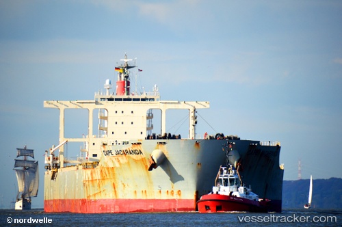
 Cape Jacaranda
Current Status
Where is the vessel?
Cape Jacaranda is currently in 53 nm S of Kidd's Beach, based on AIS data received less than 1h ago.
Latest AIS update:
Current position: 33.99846° S, 27.88889° E (53 nm S of Kidd's Beach)
Average speed (last 7 days): Loading…
Average speed (last 30 days): Loading…
Vessel profile: Cape Jacaranda is a Bulk Carrier with dimensions 292m x 45m.
This page combines live AIS, route history, probable destination signals, nearby traffic, and port activity for practical vessel monitoring.
The current position of vessel Cape Jacaranda is -33.99846 lat / 27.88889 lng. Updated: 2026-05-17 23:06:21 UTCNearest reference points:
- Near Deal Party
- 21 nm S of Mount Pleasant
- 23 nm E of Port Saint John's
Currently sailing under the flag of Panama ![]()
Details:
Live Vessel Cape Jacaranda Analytics (details, animations, etc.)
Recent AIS points (UTC):
2026-05-17 19:09:02 UTC · -34.00205, 27.24380 · SOG 7.6 kn · COG 80°2026-05-17 19:32:11 UTC · -34.00085, 27.30130 · SOG 7.4 kn · COG 79°
2026-05-17 21:55:11 UTC · -33.99790, 27.67938 · SOG 8.6 kn · COG 83°
2026-05-17 23:06:21 UTC · -33.99846, 27.88889 · SOG 9 kn · COG 81°