 vesseltracker.com
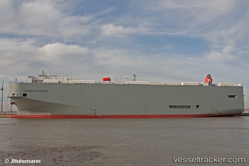
 Chesapeake Highway
Current Status
Where is the vessel?
Chesapeake Highway is currently in 18 nm NW of Villanueva de Lorenzana, based on AIS data received about 1h ago.
Latest AIS update:
Current position: 43.74074° N, 9.45257° W (18 nm NW of Villanueva de Lorenzana)
Average speed (last 7 days): Loading…
Average speed (last 30 days): Loading…
Vessel profile: Chesapeake Highway is a Vehicles Carrier with dimensions 200m x 32m.
This page combines live AIS, route history, probable destination signals, nearby traffic, and port activity for practical vessel monitoring.
The current position of vessel Chesapeake Highway is 43.74074 lat / -9.45257 lng. Updated: 2026-05-18 01:34:16 UTCNearest reference points:
- 13 nm NE of Villanueva de Lorenzana
- 30 nm NW of Meiras-Valdoviño
- Near PUNTA LANGOSTEIRA
Currently sailing under the flag of Panama ![]()
Chesapeake Highway built in 2010 year
Deadweight:
21643 tDetails:
Live Vessel Chesapeake Highway Analytics (details, animations, etc.)
Recent AIS points (UTC):
2026-05-17 22:20:46 UTC · 42.93442, -9.76664 · SOG 15.4 kn · COG 0°2026-05-17 23:30:40 UTC · 43.22793, -9.74121 · SOG 15.9 kn · COG 18°
2026-05-18 01:29:05 UTC · 43.71919, -9.46492 · SOG 16.2 kn · COG 24°
2026-05-18 01:34:16 UTC · 43.74074, -9.45257 · SOG 16.1 kn · COG 23°