 vesseltracker.com
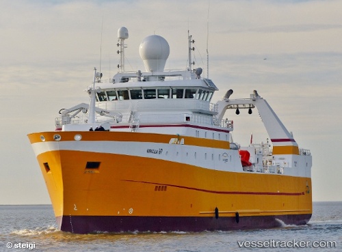
 LODAIRO
Current Status
Where is the vessel?
LODAIRO is currently in 34 nm SW of Foinaven, based on AIS data received about 1h ago.
Latest AIS update:
Current position: 59.94114° N, 5.21093° W (34 nm SW of Foinaven)
Average speed (last 7 days): Loading…
Average speed (last 30 days): Loading…
Vessel profile: LODAIRO is a Fishing Vessel with dimensions m x m.
This page combines live AIS, route history, probable destination signals, nearby traffic, and port activity for practical vessel monitoring.
The current position of vessel LODAIRO is 59.94114 lat / -5.21093 lng. Updated: 2026-05-18 04:25:56 UTCNearest reference points:
- Near Culkein
- 20 nm S of Vágur
- Near STROMNESS
Currently sailing under the flag of Spain ![]()
LODAIRO built in 2015 year
Deadweight:
3160 tDetails:
Live Vessel LODAIRO Analytics (details, animations, etc.)
Recent AIS points (UTC):
2026-05-18 01:26:39 UTC · 60.01333, -4.95333 · SOG 3 kn · COG -1°2026-05-18 01:26:39 UTC · 60.01333, -4.95333 · SOG 3 kn · COG -1°
2026-05-18 04:08:40 UTC · 59.94500, -5.18333 · SOG 2 kn · COG -1°
2026-05-18 04:25:56 UTC · 59.94114, -5.21093 · SOG 7.2 kn · COG 236°