 vesseltracker.com
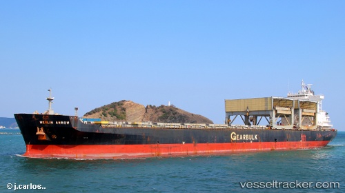
Merlin Arrow
Current StatusWhere is the vessel?
Merlin Arrow is currently in 70 nm W of NOSHIRO, based on AIS data received about 1h ago.
Latest AIS update:
Current position: 40.60104° N, 138.55067° E (70 nm W of NOSHIRO)
Average speed (last 7 days): Loading…
Average speed (last 30 days): Loading…
Vessel profile: Merlin Arrow is a Multi Purpose Carrier with dimensions 32m x 200m.
This page combines live AIS, route history, probable destination signals, nearby traffic, and port activity for practical vessel monitoring.
The current position of vessel Merlin Arrow is 40.60104 lat / 138.55067 lng. Updated: 2026-05-16 21:53:35 UTCNearest reference points:
- 63 nm NW of Sado Shima Apt
- Near Muroran
- Near Shiogama
Details:
Live Vessel Merlin Arrow Analytics (details, animations, etc.)
Recent AIS points (UTC):
2026-05-16 18:10:57 UTC · 40.93885, 139.29578 · SOG 10.8 kn · COG 235°2026-05-16 19:27:46 UTC · 40.82174, 139.03757 · SOG 10.7 kn · COG 238°
2026-05-16 21:34:56 UTC · 40.63012, 138.61336 · SOG 10.4 kn · COG 236°
2026-05-16 21:53:35 UTC · 40.60104, 138.55067 · SOG 10.8 kn · COG 236°