 vesseltracker.com
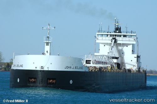
 John J Boland
Current Status
Where is the vessel?
John J Boland is currently in 46 nm NE of Christmas, based on AIS data received about 1h ago.
Latest AIS update:
Current position: 46.77500° N, 85.71333° W (46 nm NE of Christmas)
Average speed (last 7 days): Loading…
Average speed (last 30 days): Loading…
Vessel profile: John J Boland is a Self Discharging Bulk Carrier with dimensions 203m x 12m.
This page combines live AIS, route history, probable destination signals, nearby traffic, and port activity for practical vessel monitoring.
The current position of vessel John J Boland is 46.77500 lat / -85.71333 lng. Updated: 2026-05-17 02:22:48 UTCNearest reference points:
- Near Mackinaw City
- 12 nm NE of Brussels
- Near Meldrum
Currently sailing under the flag of USA ![]()
John J Boland built in 1973 year
Deadweight:
33438 tDetails:
Live Vessel John J Boland Analytics (details, animations, etc.)
Recent AIS points (UTC):
2026-05-16 22:20:23 UTC · 46.56660, -84.73555 · SOG 1.2 kn · COG 83°2026-05-16 23:53:33 UTC · 46.79357, -84.96222 · SOG 12.5 kn · COG 309°
2026-05-17 02:05:55 UTC · 46.78361, -85.62703 · SOG 12.7 kn · COG 261°
2026-05-17 02:22:48 UTC · 46.77500, -85.71333 · SOG 12 kn · COG -1°