 vesseltracker.com
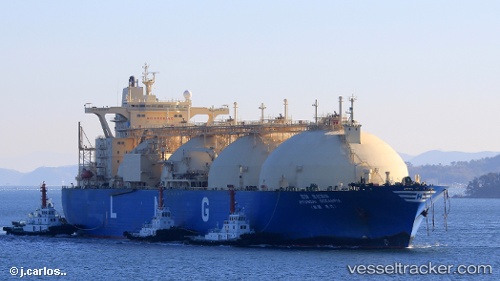
 HYUNDAI OCEANPIA
Current Status
Where is the vessel?
HYUNDAI OCEANPIA is currently in Open sea, approx. 448 nm off the nearest listed port, based on AIS data received less than 1h ago.
Latest AIS update:
Current position: 19.62674° N, 135.72856° E (Open sea, approx. 448 nm off the nearest listed port)
Average speed (last 7 days): Loading…
Average speed (last 30 days): Loading…
Vessel profile: HYUNDAI OCEANPIA is a LNG Tanker with dimensions 288m x 48m.
This page combines live AIS, route history, probable destination signals, nearby traffic, and port activity for practical vessel monitoring.
The current position of vessel HYUNDAI OCEANPIA is 19.62674 lat / 135.72856 lng. Updated: 2026-05-18 07:45:13 UTCNearest reference points:
- Open sea, approx. 448 nm off the nearest listed port
- Open sea, approx. 449 nm off the nearest listed port
- Open sea, approx. 445 nm off the nearest listed port
Currently sailing under the flag of Marshall Islands ![]()
HYUNDAI OCEANPIA built in 2000 year
Deadweight:
77512 tDetails:
Live Vessel HYUNDAI OCEANPIA Analytics (details, animations, etc.)
Recent AIS points (UTC):
2026-05-18 04:20:15 UTC · 20.48015, 135.23982 · SOG 16.7 kn · COG 151°2026-05-18 05:49:54 UTC · 20.11414, 135.45242 · SOG 17.2 kn · COG 151°
2026-05-18 06:36:42 UTC · 19.91593, 135.56686 · SOG 17.5 kn · COG 151°
2026-05-18 07:45:13 UTC · 19.62674, 135.72856 · SOG 16.8 kn · COG 150°