 vesseltracker.com
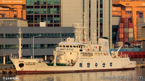
 Hanvit
Current Status
Where is the vessel?
Hanvit is currently in 48 nm SE of Sansha, based on AIS data received about 1h ago.
Latest AIS update:
Current position: 26.45704° N, 120.93461° E (48 nm SE of Sansha)
Average speed (last 7 days): Loading…
Average speed (last 30 days): Loading…
Vessel profile: Hanvit is a Fishing Support Vessel with dimensions m x m.
This page combines live AIS, route history, probable destination signals, nearby traffic, and port activity for practical vessel monitoring.
The current position of vessel Hanvit is 26.45704 lat / 120.93461 lng. Updated: 2026-05-18 04:27:40 UTCNearest reference points:
- 43 nm E of Sansha
- 58 nm E of Beijiao
- 56 nm E of Beijiao
Currently sailing under the flag of Korea ![]()
Details:
Live Vessel Hanvit Analytics (details, animations, etc.)
Recent AIS points (UTC):
2026-05-18 01:43:16 UTC · 27.06630, 121.31483 · SOG 15.9 kn · COG 215°2026-05-18 01:43:46 UTC · 27.06451, 121.31341 · SOG 15.8 kn · COG 214°
2026-05-18 03:26:52 UTC · 26.68435, 121.06407 · SOG 15.4 kn · COG 209°
2026-05-18 04:27:40 UTC · 26.45704, 120.93461 · SOG 15 kn · COG 212°