 vesseltracker.com
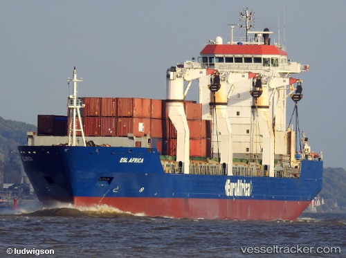
 Esl Africa
Current Status
Where is the vessel?
Esl Africa is currently in 33 nm NW of Farta Bay, based on AIS data received less than 1h ago.
Latest AIS update:
Current position: 12.15896° S, 12.90373° E (33 nm NW of Farta Bay)
Average speed (last 7 days): Loading…
Average speed (last 30 days): Loading…
Vessel profile: Esl Africa is a Multi Purpose Carrier with dimensions 141m x 22m.
This page combines live AIS, route history, probable destination signals, nearby traffic, and port activity for practical vessel monitoring.
The current position of vessel Esl Africa is -12.15896 lat / 12.90373 lng. Updated: 2026-05-17 05:24:41 UTCCurrently sailing under the flag of Cyprus ![]()
Esl Africa built in 2007 year
Deadweight:
17356 tDetails:
Live Vessel Esl Africa Analytics (details, animations, etc.)
Recent AIS points (UTC):
2026-05-17 01:45:13 UTC · -12.02833, 12.21167 · SOG 11 kn · COG -1°2026-05-17 03:47:27 UTC · -12.09834, 12.59577 · SOG 10.9 kn · COG 102°
2026-05-17 04:03:16 UTC · -12.10779, 12.64536 · SOG 11.1 kn · COG 100°
2026-05-17 05:24:41 UTC · -12.15896, 12.90373 · SOG 11.2 kn · COG 111°