 vesseltracker.com
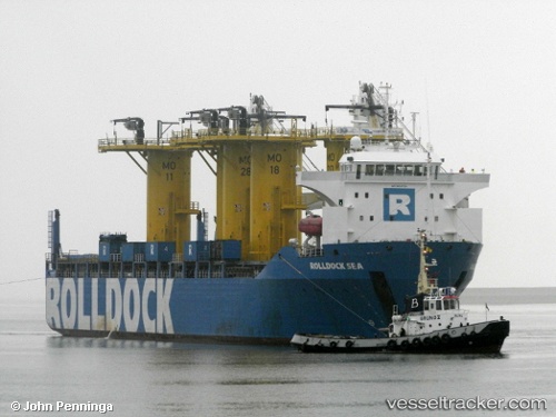
 Rolldock Sea
Current Status
Where is the vessel?
Rolldock Sea is currently in 15 nm NW of Mölle, based on AIS data received less than 1h ago.
Latest AIS update:
Current position: 56.50078° N, 12.26758° E (15 nm NW of Mölle)
Average speed (last 7 days): Loading…
Average speed (last 30 days): Loading…
Vessel profile: Rolldock Sea is a Heavy Load Carrier with dimensions 139m x 24m.
This page combines live AIS, route history, probable destination signals, nearby traffic, and port activity for practical vessel monitoring.
The current position of vessel Rolldock Sea is 56.50078 lat / 12.26758 lng. Updated: 2026-05-17 08:16:26 UTCNearest reference points:
- 11 nm NW of Tisvilde
- Near FALKENBERG
- Near Viken
Currently sailing under the flag of Netherlands ![]()
Rolldock Sea built in 2011 year
Deadweight:
6879 tDetails:
Live Vessel Rolldock Sea Analytics (details, animations, etc.)
Recent AIS points (UTC):
2026-05-17 04:05:26 UTC · 57.24464, 11.82167 · SOG 11.9 kn · COG 138°2026-05-17 05:29:26 UTC · 57.00109, 11.99739 · SOG 11.3 kn · COG 165°
2026-05-17 07:11:05 UTC · 56.69229, 12.16880 · SOG 11.2 kn · COG 168°
2026-05-17 08:16:26 UTC · 56.50078, 12.26758 · SOG 10.8 kn · COG 172°