 vesseltracker.com
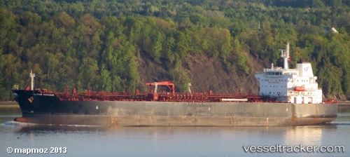
 SWIFT OMAHA
Current Status
Where is the vessel?
SWIFT OMAHA is currently in 114 nm W of Cap Skiring, based on AIS data received less than 1h ago.
Latest AIS update:
Current position: 12.14262° N, 18.67024° W (114 nm W of Cap Skiring)
Average speed (last 7 days): Loading…
Average speed (last 30 days): Loading…
Vessel profile: SWIFT OMAHA is a Chemical/Oil Products Tanker with dimensions 32m x 183m.
This page combines live AIS, route history, probable destination signals, nearby traffic, and port activity for practical vessel monitoring.
The current position of vessel SWIFT OMAHA is 12.14262 lat / -18.67024 lng. Updated: 2026-05-18 05:47:51 UTCNearest reference points:
- 48 nm W of Cap Skiring
- 144 nm SW of Bubaque
- Near San Francisco Libre
Currently sailing under the flag of Marshall Islands ![]()
SWIFT OMAHA built in 2010 year
Deadweight:
46087 tDetails:
Live Vessel SWIFT OMAHA Analytics (details, animations, etc.)
Recent AIS points (UTC):
2026-05-18 01:35:50 UTC · 12.92427, -18.29976 · SOG 12 kn · COG 200°2026-05-18 04:10:22 UTC · 12.44594, -18.52825 · SOG 12.2 kn · COG 205°
2026-05-18 04:56:41 UTC · 12.30192, -18.59590 · SOG 12.2 kn · COG 206°
2026-05-18 05:47:51 UTC · 12.14262, -18.67024 · SOG 11.9 kn · COG 206°