 vesseltracker.com
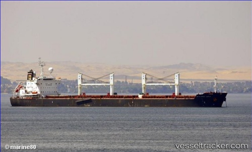
 Abu Al Abyad
Current Status
Where is the vessel?
Abu Al Abyad is currently in 13 nm E of Mundra Port SEZ, based on AIS data received less than 1h ago.
Latest AIS update:
Current position: 22.78323° N, 69.96491° E (13 nm E of Mundra Port SEZ)
Average speed (last 7 days): Loading…
Average speed (last 30 days): Loading…
Vessel profile: Abu Al Abyad is a Bulk Carrier with dimensions 190m x 32m.
This page combines live AIS, route history, probable destination signals, nearby traffic, and port activity for practical vessel monitoring.
The current position of vessel Abu Al Abyad is 22.78323 lat / 69.96491 lng. Updated: 2026-05-17 17:08:25 UTCNearest reference points:
- 12 nm N of Rozi
- 15 nm N of Rozi
- Near Rozi
Currently sailing under the flag of Liberia ![]()
Abu Al Abyad built in 2011 year
Deadweight:
57369 tDetails:
Live Vessel Abu Al Abyad Analytics (details, animations, etc.)
Recent AIS points (UTC):
2026-05-17 13:17:25 UTC · 22.78204, 69.96102 · SOG 0 kn · COG 45°2026-05-17 14:08:25 UTC · 22.78193, 69.96107 · SOG 0 kn · COG 41°
2026-05-17 15:17:25 UTC · 22.78164, 69.96145 · SOG 0 kn · COG 24°
2026-05-17 17:08:25 UTC · 22.78323, 69.96491 · SOG 0.1 kn · COG 244°