 vesseltracker.com
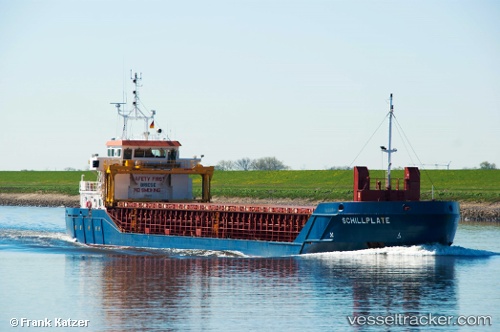
Vessel Schillplate IMO: 9505285, MMSI: 236111603 Multi Purpose Carrier
UTC, 41.25333, -10.08833, course: -1, speed: 9
UTC, 40.94500, -10.09833, course: -1, speed: 9
2026-02-08 15:50:45 UTC, 40.60167, -10.10167, course: -1, speed: 8
Live AIS position:
UTC. 58 nm W of Canas de Santa Maria),
updated 2026-02-08 15:50:45 UTC.
Find the position of the vessel Schillplate on the map. The latter are known coordinates and path.
marine traffic ship tracker show on live map
The current position of vessel Schillplate is 40.60167 lat / -10.10167 lng. Updated: 2026-02-08 15:50:45 UTCCurrently sailing under the flag of Gibraltar
Schillplate built in 2009 year
Deadweight:
3175 tDetails:
Last coordinates of the vessel:
UTC, 41.55384, -10.08113, course: 185, speed: 9.5UTC, 41.25333, -10.08833, course: -1, speed: 9
UTC, 40.94500, -10.09833, course: -1, speed: 9
2026-02-08 15:50:45 UTC, 40.60167, -10.10167, course: -1, speed: 8