 vesseltracker.com
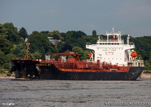
Chemroute Sky
Current StatusWhere is the vessel?
Chemroute Sky is currently in 55 nm W of New Mangalore, based on AIS data received less than 1h ago.
Latest AIS update:
Current position: 12.06269° N, 73.86266° E (55 nm W of New Mangalore)
Average speed (last 7 days): Loading…
Average speed (last 30 days): Loading…
Vessel profile: Chemroute Sky is a Chemical Oil Products Tanker with dimensions 26m x 156m.
This page combines live AIS, route history, probable destination signals, nearby traffic, and port activity for practical vessel monitoring.
The current position of vessel Chemroute Sky is 12.06269 lat / 73.86266 lng. Updated: 2026-05-17 13:08:41 UTCNearest reference points:
- 57 nm NW of New Mangalore
- Near Mangalore
- 17 nm NW of Panamburu
Details:
Live Vessel Chemroute Sky Analytics (details, animations, etc.)
Recent AIS points (UTC):
2026-05-17 10:11:20 UTC · 11.41019, 74.13160 · SOG 14.3 kn · COG 339°2026-05-17 10:11:20 UTC · 11.41019, 74.13160 · SOG 14.3 kn · COG 339°
2026-05-17 10:11:20 UTC · 11.41019, 74.13160 · SOG 14.3 kn · COG 339°
2026-05-17 13:08:41 UTC · 12.06269, 73.86266 · SOG 14 kn · COG 350°